Travel
Beyond Mount Everest: 10 Hidden Natural Wonders of Nepal—and What Makes Each Remarkable
EverestBlog AI · Nov 1, 2026 · 16 min read
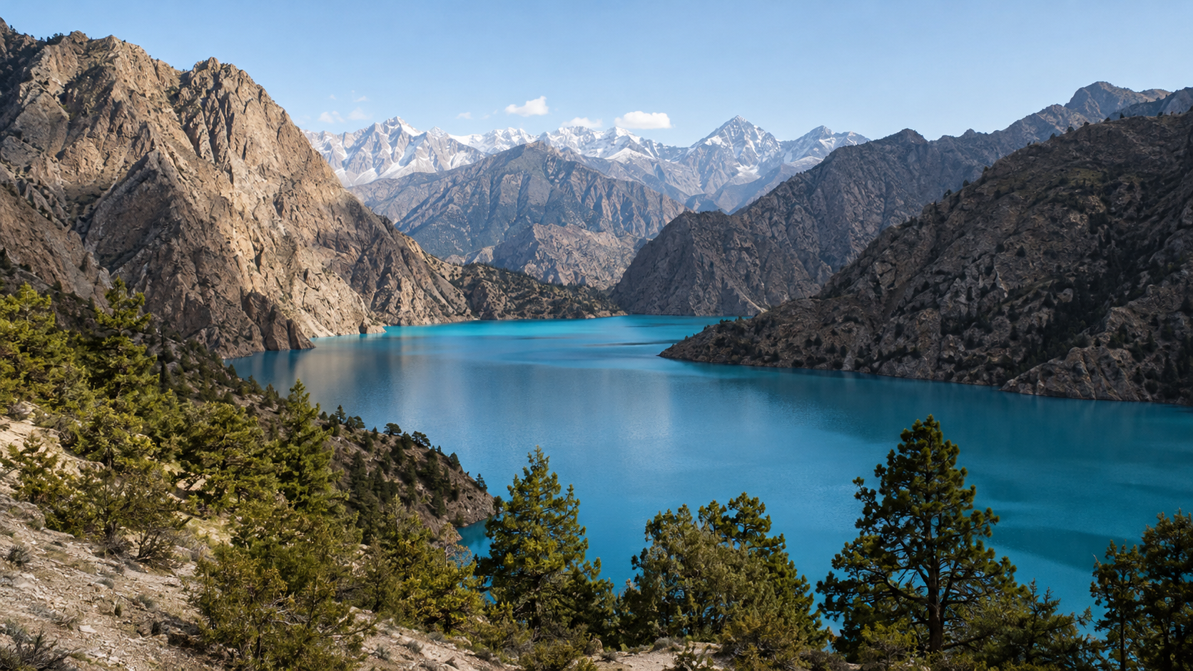
Phoksundo Lake in Dolpa: one of ten Nepal landscapes selected for distinctive natural features rather than claims of being undiscovered. · AI-generated illustration
Everest may draw your eyes upward, but Nepal rewards looking in other directions too: across a high lake, into a river-cut valley, beneath a limestone hillside, or along the wet edge of a forest pond. A landscape-first journey begins with those features rather than a summit checklist. It asks what water, rock, altitude and living habitats have made in each place—and what you can actually notice when you arrive. The result is a different way to explore Nepal, with attention rather than elevation as the measure of a memorable visit.
This guide brings together ten hidden places in Nepal, with an important qualification: “hidden” does not mean unknown, uninhabited or undiscovered. Several are well known within their regions, and some have long attracted pilgrims, trekkers or domestic travellers. They are also part of places where people live, work, worship and manage natural resources. Here, the phrase simply points beyond the Everest-centred picture that often shapes an overseas visitor’s first impression. Finding somewhere unfamiliar to you is not the same as finding somewhere nobody knows.
Our selection rule is straightforward: every destination must offer a distinctive, observable natural feature. Remoteness alone is not enough, and neither is a reputation for beauty. A lake should invite attention to its setting, shoreline or surrounding relief. A gorge should reveal something about the relationship between a river and the mountains around it. A wetland or meadow should offer more than a backdrop for photographs. You should leave able to describe what made that landscape different, without relying on words such as “magical” or “untouched.”
The journey starts with mountain water at Phoksundo, Rara and Panch Pokhari, then turns to rock and relief in Mustang, the Kali Gandaki corridor, the Barun Valley and Siddha Gufa. It finishes with the living landscapes of Khaptad, Dhorpatan and Mai Pokhari. These names do not all describe equivalent units: a lake, a cave, a broad region and a river corridor need different kinds of explanation. Keeping that distinction clear helps prevent a familiar travel-writing mistake—assigning the characteristics of one viewpoint or trail to an entire destination.
It also changes how you plan. These ten places are a set of possibilities, not a single practical circuit. Distances on a map say little about road surfaces, walking time, weather exposure or the effort of reaching a remote trailhead. Choose a journey that suits your available time, fitness and comfort with uncertainty. Allow space to observe rather than collecting stops: watch how a shoreline meets the hills, compare exposed rock with vegetated slopes, or notice where dry ground becomes marsh. None of that requires a dramatic claim about being first, deepest or highest.
Season and access need separate attention. Rain, snow and changing water levels can alter both the view and the approach; a landscape description is not evidence that a route is currently usable. For changing permits, trail conditions and opening arrangements, check locally with the responsible office and reliable people near the destination. Ask specific questions about your intended route and travel period, especially where altitude, caves or remote walking are involved. Treat sacred waters, grazing areas and fragile wetland edges with care, and follow local guidance rather than assuming every attractive spot is open to visitors.
Publication verification note: This introduction does not certify completed source checks. Before publication, verify all ten locations, spellings, administrative areas and landscape claims against relevant Department of National Parks and Wildlife Conservation (DNPWC), National Trust for Nature Conservation (NTNC), Ramsar and geological references, supplemented by reliable local sources. Resolve alternate spellings and distinguish named sites from surrounding regions. Confirm current access separately; protected-area descriptions and geological accounts do not establish today’s travel conditions. Where arrangements change, retain “check locally” rather than presenting uncertain information as settled fact.
1–3. Mountain Water: Phoksundo, Rara and Panch Pokhari
Water gives these three hidden places in Nepal very different identities. At Phoksundo, the drama comes from a lake pressed against steep rock. At Rara, the surrounding forest shapes the shoreline experience. At Panch Pokhari, five lakes invite you to read the wider mountain landscape rather than concentrate on a single stretch of water.
1. Phoksundo Lake, Dolpa
Location: Phoksundo lies in Dolpa, within Shey Phoksundo National Park in northwestern Nepal. Its signature feature is striking blue-green water enclosed by steep mountain walls. The first impression can feel almost graphic: a smooth expanse of water beneath broken cliffs, with sparse vegetation softening only parts of the scene.
Look beyond the broad view and notice where these surfaces meet. Along exposed sections of shore, rock seems to drop directly towards the water. Elsewhere, patches of vegetation provide a quieter boundary. These changes help reveal the scale of the enclosing slopes, which can be difficult to judge in a photograph without a familiar reference point.
Watch how cloud cover, sunlight and your viewing angle change the lake’s appearance. Describe what you see rather than assuming a particular mineral or other substance explains its colour. A visual impression alone cannot establish the cause.
Why it matters: Phoksundo is remarkable for the contrast between water, rock and limited plant cover. Give yourself time at a safe viewpoint instead of chasing a more exposed photograph. Ringmo, near the lake, also places this landscape within a lived cultural setting; respect local religious sites and ask before photographing people.
2. Rara Lake, Mugu
Location: Rara Lake lies in Mugu, within Rara National Park in northwestern Nepal. Here, a broad body of water is framed by forested slopes. Rather than treating it as another lake defined by colour, follow the relationship between the open water and the wooded land around it.
From the shoreline, look for alternating views: trees close beside the path, small openings towards the lake, and longer perspectives across to the opposite slopes. Each opening changes the composition. A nearby branch can frame the distant shore, while a wider clearing makes the lake’s breadth easier to appreciate.
Reflections offer another way to observe this setting. In calm conditions, the forested slopes may appear doubled on the surface. When wind breaks that reflection, the same view becomes a study in movement. Neither experience is guaranteed, so allow time to pause rather than planning your visit around one expected photograph.
Why it matters: Rara’s character comes from the lake and forest together. The shoreline is their meeting place, not simply a route to a viewpoint. Walk quietly, remain on established paths and avoid disturbing birds near the water. For access arrangements, accommodation and current trail conditions, check locally; reaching this remote area requires flexibility.
3. Panch Pokhari, Sindhupalchok
Location: This Panch Pokhari is the high-altitude group of five lakes in Sindhupalchok, northeast of Kathmandu. The name means “five ponds” and is used for other places in Nepal, so specify the district when discussing routes, guides or transport.
Its defining feature is the group itself: five lakes set within an alpine landscape. Spend time looking at individual shorelines, but also seek an established, safe viewpoint that shows how several lakes sit together. You need not see every lake at once to understand the arrangement; comparing views as you walk can be equally revealing.
Notice the ground separating the water bodies, the slopes rising around them and the differing shapes of their margins. Seen together, these features show how water occupies distinct hollows in mountain terrain. Avoid assuming that neighbouring lakes are visibly connected or share identical conditions.
Why it matters: The wider view makes Panch Pokhari more than five separate destinations. It is also a sacred pilgrimage landscape. Respect worshippers and shrines, carry out litter, and plan a gradual ascent: altitude deserves attention even when the walking distance looks manageable.
4–7. Rock and Relief: Mustang, Kali Gandaki, Barun and Siddha Gufa
4. Upper Mustang: A Landscape Carved by Wind and Water
Upper Mustang’s cliffs, gullies and broken ridgelines reveal a Himalayan landscape shaped as much by erosion as by mountain building. Much of the region lies in the rain shadow of high mountains: moist air loses much of its water before reaching this northern terrain. The result is a dry landscape where exposed rock and sediment often dominate the view.
Look closely at the slopes rather than treating them as a distant backdrop. Water running through softer material cuts channels that branch into narrow gullies, while wind helps wear away and redistribute loose particles. Different layers resist erosion differently, leaving ledges, pillars and deeply fluted faces.
Dry does not mean lifeless. Hardy shrubs, seasonal grasses and cultivated patches around settlements show how life responds to scarce water. Walk established trails and notice where greenery gathers beside streams or irrigation channels. Upper Mustang has special permit requirements; check locally for current access rules and guiding arrangements before planning your route.
5. Kali Gandaki Gorge: Reading the Valley’s Vertical Scale
Along the Dana–Ghasa stretch, the Kali Gandaki runs through dramatic relief between the broader Annapurna and Dhaulagiri massifs. Its force has helped cut into a landscape also shaped by tectonic uplift, tributary streams and slope failures. The remarkable feature is not a record-book label, but the contrast between the river corridor and the mountains rising around it.
To appreciate that scale, stop at a safe, open location away from traffic and unstable edges. Begin with the river, then trace your gaze up the lower slopes, across hanging side valleys and toward higher ridges. Clouds and intervening slopes may hide the tallest peaks; a map helps connect what you can see with the larger mountain setting.
Among these hidden places in Nepal, this gorge rewards patient observation more than a rushed roadside photograph. Road works, dust and landslide conditions can affect the experience, so check locally before travelling. Never step beneath loose cliffs simply to find a clearer angle.
6. Barun Valley: Vegetation Changes with Every Climb
Within Makalu Barun National Park, Barun Valley combines steep mountain walls with striking changes in vegetation along its elevation gradient. Moist, forested lower slopes support a very different world from the exposed terrain higher up. As a trek gains height, broadleaf forest gives way to cooler woodland, including rhododendrons and conifers where conditions suit them, then to alpine shrubs, grasses and increasingly bare rock.
This is not a sequence that one viewpoint neatly displays. You experience it over successive walking days, and the transitions vary with slope direction, moisture and local terrain. A shaded slope may hold dense vegetation while a nearby exposed face looks much harsher.
Watch the small changes: trees becoming shorter, openings widening, and plants hugging the ground as shelter decreases. These details make the valley more than a corridor toward Makalu. Access involves remote trekking with limited services; arrange suitable support, allow time for acclimatisation and check locally for trail, weather and park-entry conditions.
7. Siddha Gufa: Water’s Slow Work Underground
Near Bandipur in Tanahun, Siddha Gufa offers a different view of Nepal’s geology: the inside of a limestone landscape. Rainwater absorbs carbon dioxide from the air and soil, becoming mildly acidic. As it seeps through cracks, it slowly dissolves limestone, widening passages and cavities over long periods.
Inside the cave, the process can reverse. Dripping water releases carbon dioxide and leaves behind tiny deposits of calcium carbonate. Repeated deposition builds formations such as stalactites hanging from ceilings and stalagmites rising from floors.
Explore with a local guide, carry a reliable torch and wear footwear with good grip on damp, uneven surfaces. Check locally for access arrangements. Do not touch mineral formations: skin oils and dirt can contaminate their surfaces, and delicate growth can break easily. Leave the cave exactly as you find it.
8–10. Living Landscapes: Khaptad, Dhorpatan and Mai Pokhari
Some hidden places in Nepal are remarkable not for a single peak or waterfall, but for the way whole landscapes fit together. Khaptad, Dhorpatan and Mai Pokhari offer three different versions of this: grassland woven through woodland, a broad valley shaped by pastoral life, and a wetland whose edges are as interesting as its open water. Slow walking helps reveal the differences.
8. Khaptad National Park: Meadows Between the Trees
In Nepal’s far west, Khaptad National Park opens into upland grasslands interrupted by patches of forest. Its defining feature is this meadow–woodland mosaic: rounded grassy ground, wooded slopes and tree-lined openings that appear and disappear as you walk. Rather than looking for one commanding viewpoint, notice how the landscape changes at each forest edge.
The contrast is easy to appreciate on foot. Under the trees, the path can feel enclosed and shaded; beyond them, the grasslands bring a wider sky and a stronger sense of the rolling terrain. Follow established trails between these spaces rather than cutting across the meadows. Wildlife lives here, but sightings should not be the measure of a rewarding visit.
Season changes both colour and access. During the wetter months, grasslands generally become greener, while mist may soften or hide the surrounding contours. After the rains, vegetation gradually loses some of its fresh green. Cold weather can bring frost or snow, changing the texture of the open ground and making walking harder. Flowers and distant views depend on conditions, not simply the month.
Plan for: a remote walking trip with changeable weather. Check locally for trail conditions, park entry requirements, guides and accommodation before setting out.
9. Dhorpatan Valley: A Highland Landscape with Daily Life
Dhorpatan Valley lies within Dhorpatan Hunting Reserve, but its appeal need not involve hunting or searching for animals. The landscape itself deserves attention: an expansive highland valley with open pasture across its floor and forest along its margins. The eye follows the length of the valley rather than moving between Khaptad’s rolling meadow openings.
That valley-floor landform is the key distinction. Stand on an established path and look from the open centre towards the wooded sides. The broad space between them makes the shape of the valley readable, even when cloud covers the higher ground. Walking here is about understanding that spacious setting, not collecting summit views.
Dhorpatan is also a lived-in pastoral landscape. Settlements, livestock and grazing activity are part of its character, not distractions from an otherwise empty wilderness. Give animals room, avoid blocking working paths and ask before photographing residents. Do not assume that open pasture is available for camping; seek local advice and permission.
Wet-season growth can make the valley greener, although rain and low cloud may complicate travel. In drier or colder periods, pasture can look more muted, and frost or snow may affect access. Pastoral activity also varies through the year. Check locally for road and trail conditions, lodging and reserve requirements; arrange the visit around walking and village life rather than safari-style expectations.
10. Mai Pokhari, Ilam: Where Water Meets Forest
Mai Pokhari, in Ilam’s mid-hills, is a forest-fringed wetland recognized as a Ramsar site. Its interest lies in the meeting of water and vegetation: shaded banks, plants at the margins and forest reflected on the surface. Look closely at these boundaries rather than treating the wetland as a quick photo stop.
Stay on established paths and observe how the edge changes around the water. Some stretches feel enclosed by trees; others offer a more open view. These margins form part of the wetland habitat, so avoid trampling plants or disturbing the banks.
Rain, cloud and seasonal growth alter its appearance. Wetter periods can bring lush vegetation and slippery paths; cooler or drier conditions may change water levels and colours. Neither clear reflections nor particular sightings are guaranteed. Check locally for access conditions, and keep noise low.
Conclusion: Travel for What Makes Each Place Different
The strongest reason to look beyond Everest is not to collect places that other travellers have missed. It is to discover how differently Nepal’s landscapes work, and how much more you notice when you give them time. A lake becomes more than a photograph when you watch its surface change with the wind. A meadow means more when you understand who grazes animals there. The reward is attention, not exclusivity.
Even the phrase hidden places in Nepal needs care. These places are not hidden from the people who live beside them, worship there or depend on them. Some are established pilgrimage destinations; others sit within protected areas or working countryside. Arriving as a guest, rather than as someone claiming a discovery, changes the questions you ask and the way you travel.
Choose the experience, then test the journey
Start with the kind of landscape that holds your interest. If you enjoy watching light and weather, a waterside stay may suit you better than a route built around daily distance. If you are drawn to geology, choose somewhere you can examine landforms slowly and safely. If birds, plants or pastoral life interest you most, allow time for quiet walks rather than expecting a single dramatic viewpoint to deliver the experience.
Then compare that preference with your actual travel capacity. Fitness matters, but so do available days, comfort with basic accommodation, altitude experience and tolerance for delays. A destination that looks close on a map may require a complicated approach. Ask what an ordinary travel day involves: hours on foot, road conditions, sleeping elevation, food availability and options for turning back. Choose the journey you can manage, not the one that sounds most impressive.
- With limited time: favour a manageable base and fewer transfers. Leave room for a slow walk or an unexpected conversation instead of adding another distant stop.
- With more time but little trekking experience: build in acclimatisation where needed, keep daily distances realistic and seek advice before committing to remote routes.
- With experience and flexibility: consider a longer journey, but retain spare days. Experience does not remove weather, altitude or access problems.
These ten places are a selection, not a single practical itinerary. They are spread across Nepal, with different access arrangements and seasonal conditions. Linking them all would make transport the centre of the trip. A better plan usually combines one main landscape with nearby walks or settlements that fit naturally into the journey. For current permits, transport, accommodation, trail access and guide requirements, check locally before finalising arrangements.
Let care shape the visit
Use appropriate local guidance, particularly for remote terrain, unfamiliar trails, cave visits or places with cultural restrictions. Ask protected-area staff, knowledgeable hosts or qualified guides what is suitable for your experience and the conditions. Explain what you hope to see and how far you can comfortably travel. Good guidance should help you make informed choices, including the choice to shorten a walk or abandon an unsafe plan.
Remember that sacred and working landscapes are not open-air exhibits. Ask before entering shrines, photographing ceremonies or crossing land in use. Give livestock space, avoid disturbing herding work and follow local advice about behaviour near holy water or religious sites. Stay on established routes rather than making shortcuts through fragile vegetation. Carry out your waste, including food packaging and tissues; do not assume a remote settlement can process what you leave behind.
Finally, leave some time unassigned. Sit quietly, look again, and ask a respectful question when someone is willing to talk. You may return with fewer stops completed, but a clearer understanding of what made one valley, wetland or hillside distinct. That is a more lasting way to travel beyond Everest: not searching for somewhere nobody knows, but learning to see a place on its own terms.