Culture
The Ancient History of Kathmandu Valley: A Civilization Built Through Time
EverestBlog AI · Nov 1, 2026 · 21 min read
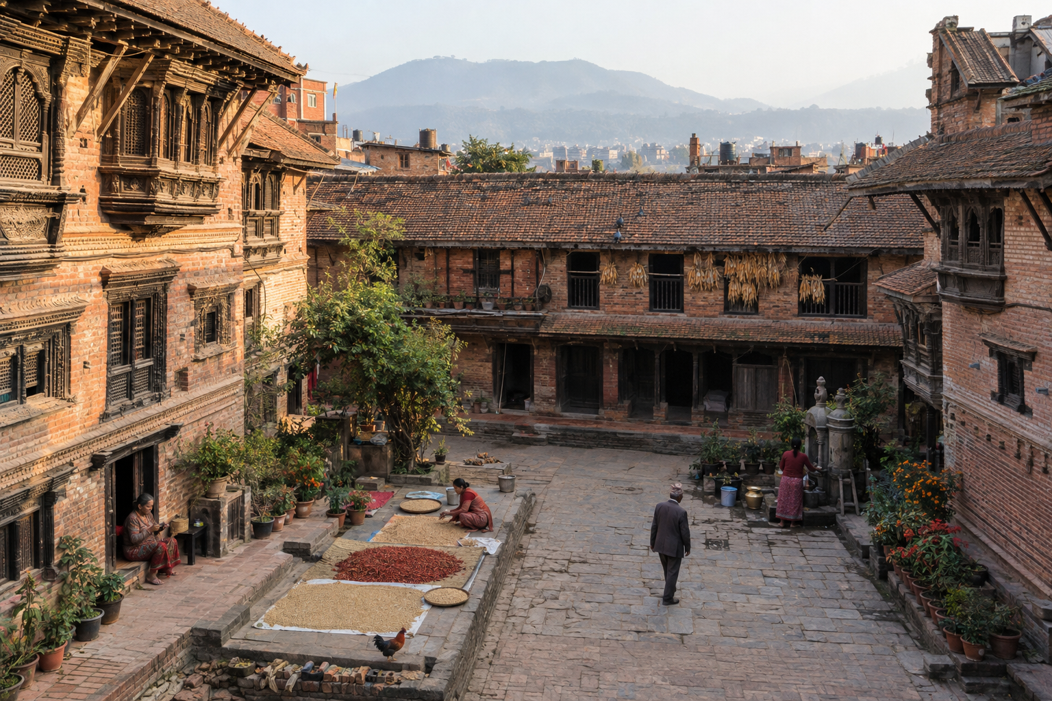
Bhaktapur’s courtyards and closely spaced homes reflect the Kathmandu Valley’s long development of shared urban space. · AI-generated illustration
The history of Kathmandu Valley is not simply a story of rulers, palaces and changing power. It is also the gradual making of a place where people could settle, grow food, exchange goods and live together in increasingly complex communities. Its cities took shape through countless decisions about land, water, worship and shared space. Reading that history means looking beyond royal monuments to the courtyards, paths, ponds and neighbourhoods that made everyday life possible.
In Kathmandu, Patan and Bhaktapur, the past remains part of the working landscape. A public square may serve as a market, a meeting place and a setting for ritual. A courtyard can connect households while preserving a religious or social purpose. A stone water spout may reveal older relationships between engineering, belief and public provision. These places are not unchanged fragments of antiquity. They have been repaired, rebuilt and adapted, often many times, and their histories include both continuity and loss.
This article approaches the valley as a landscape made habitable and then made urban. Its physical beginnings matter because the basin’s ancient lake environments, sediments and drainage helped shape the ground on which later communities lived. Yet geology alone cannot explain the rise of settlements. Farming, movement, trade, religious institutions and arrangements for managing resources all contributed. The central question is not only who held authority, but how people organised life in a valley that became a closely connected network of towns and cultivated land.
To keep different kinds of knowledge clear, the article uses three evidence labels. Each answers a different question, and none should be silently substituted for another.
- Documented history refers to claims supported by identifiable historical evidence, such as inscriptions, dated records and archaeological findings. An inscription may establish that a donation was made or an institution existed at a particular time. It does not automatically reveal how every household lived. Surviving evidence is uneven, and public or religious acts often leave clearer traces than ordinary work.
- Historical interpretation describes an explanation built by comparing evidence and drawing reasoned connections. Researchers may use settlement patterns, buildings, texts and landscape features to consider how an urban centre developed. Such explanations can be persuasive without being certain in every detail. Where evidence allows more than one reading, that uncertainty matters.
- Origin tradition identifies stories through which communities explain the valley’s beginnings and sacred significance. Accounts associated with Manjushri and the opening of the valley belong here. They are important expressions of cultural memory and religious meaning, but they should not be treated as dated eyewitness accounts of geological change.
These labels are not a ranking of cultural importance. A tradition can shape how a landscape is understood for centuries, while an inscription may preserve only a narrow transaction. The distinction concerns what each source can establish. Geological evidence for a former lake, for example, does not by itself prove the events of a sacred narrative. Likewise, the earliest surviving written mention of a settlement need not mark the moment that people first lived there.
The journey ahead moves from the basin’s physical formation and early habitation to the clearer written record of the Licchavi period, then follows the growth of settlement networks into urban centres. It considers how water systems, courtyards and collective responsibilities supported medieval city life, and how that inheritance survives under modern pressure. Throughout, the focus remains on the making and maintenance of urban society, including the long contribution of Newar communities. The aim is to recognise Kathmandu Valley not as a finished monument to the past, but as an inherited landscape whose survival depends on the people and practices that continue to sustain it.
Before the Written Record: A Lake Basin Becomes Habitable
Long before inscriptions named rulers or recorded donations, water shaped the Kathmandu Valley. Its broad floor was once occupied by an ancient lake system, with rivers carrying material down from the surrounding hills. The earliest background to the history of Kathmandu Valley therefore lies in its geology: layers of sediment that reveal how a watery basin gradually became land where people could live and cultivate crops.
Evidence for this lake survives beneath the modern landscape. Fine clay and silt settled in quiet water, while sand and gravel accumulated where streams entered the basin or flowed through it. Geologists study these deposits in exposed ground and boreholes to reconstruct changing environments. Fossil pollen and plant remains preserved in some layers also offer clues to past vegetation and climate. Together, these materials show that the valley floor developed through a long sequence of deposition, shifting waterways and changing lake levels.
This was not a landscape that became dry and habitable all at once. Water levels changed over time, and different parts of the basin experienced different conditions. Sediment built up in some areas while rivers cut into others. Changes in drainage through the southern outlet, near the Chobhar gorge, contributed to the lake’s eventual disappearance. Geological research supports a complex history rather than a single, securely dated moment when the entire valley emptied.
As water withdrew, it left a varied landscape of exposed lake beds, river channels, wet ground and higher terraces. Some surfaces would have become usable sooner than others. Low-lying areas could remain marshy or vulnerable to flooding, even when nearby ground was dry. Becoming habitable was therefore a gradual and uneven process: land suitable for cultivation was not necessarily equally suitable for a permanent home.
The valley also has a powerful cultural explanation for this transformation. In a well-known Buddhist origin tradition, Manjushri, the bodhisattva associated with wisdom, encounters a sacred lake and cuts an opening at Chobhar with his sword, allowing the water to drain. The story is closely connected with the sacred landscape of Swayambhu and gives spiritual meaning to the emergence of the valley.
This account should be understood as an origin tradition, not a dated historical event. It matters because it expresses how communities have understood their homeland, its sacred places and its relationship with water. The presence of a real former lake makes the comparison compelling, but it does not establish the sword-cutting episode as a geological explanation. Cultural tradition and physical evidence illuminate different aspects of the valley’s past.
The emerging land offered important opportunities. Lake and river deposits helped create soils that could support farming, although fertility and drainage varied from place to place. Rivers supplied fresh water and could support irrigation, while adjoining slopes offered access to woodland and other resources. Higher ground near cultivable land may have been attractive because it combined access to water with some protection from floods. These are plausible advantages, however, not proof of where the first inhabitants settled.
The timing and locations of the earliest settlements remain incompletely understood. Later construction, deep sediment and the long occupation of favourable sites can conceal or disturb early traces. Archaeological finds must also be assessed carefully: evidence that people visited an area does not automatically demonstrate a permanent farming settlement. There is no sound basis for assigning the whole valley a single founding date or one founding people. Its earliest habitation is better approached as an open field of enquiry, shaped by changing environments and human choices whose details are still only partly visible.
The Licchavi Record: Settlements Become Historically Visible
The history of Kathmandu Valley becomes easier to trace when surviving inscriptions begin to name rulers, places and institutions. For the Licchavi period, these carved records offer firmer evidence than later legends alone. They do not provide a complete account of life in the valley, but they anchor particular people and actions in time. Read carefully, they reveal a society with established settlements, cultivated land, religious communities and recognised forms of authority.
A Written Anchor at Changu Narayan
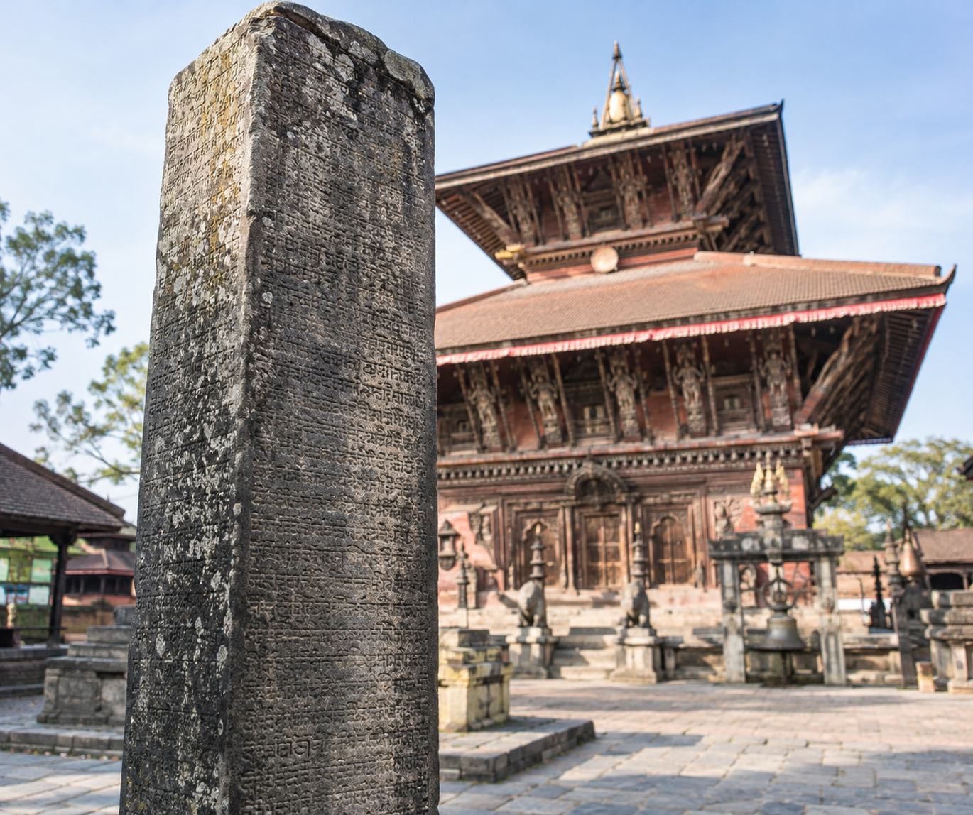
One of the most important records stands at Changu Narayan, the hilltop temple northeast of Bhaktapur. Its Sanskrit inscription, dated to 464 CE and associated with King Manadeva, is a key reference point for early Nepalese history. It records royal ancestry and achievements while expressing devotion to Vishnu. Unlike a story passed down and written much later, it provides evidence produced within the period being studied.
Even this valuable source needs careful handling. A royal inscription was not a neutral report. It presented a ruler as legitimate, capable and worthy of remembrance. Its account therefore tells us both about events and about the image the court wished to preserve. The inscription also does not date every structure now visible at Changu Narayan: the temple complex has undergone rebuilding and repair over many centuries.
Settlements, Fields and Rights to Land
Other Licchavi-period inscriptions broaden the picture beyond royal achievements. They mention settlements, fields, boundaries and arrangements for revenue or service. Such references show that inhabited places were connected to productive land and to authorities able to recognise or alter rights over it. They also help historians investigate the valley’s early geography, although identifying an ancient place-name with a modern neighbourhood is not always straightforward.
Landholding was more complicated than simple ownership. A grant might concern land itself, the income collected from it, or exemptions from particular demands. Rulers, officials, religious beneficiaries and cultivators could hold different interests in the same agricultural landscape. The precise wording matters: permission to receive revenue should not automatically be read as possession in the modern sense.
Agriculture supplied much of the material support behind these arrangements. References to cultivated plots, dues and donations reveal how farming sustained institutions as well as households. Where records mention water or boundaries, they also show the practical importance of defining access and responsibilities. However, they rarely explain an entire farming year or describe the daily work of those who produced the harvest.
Donations and Religious Institutions
Donative inscriptions make religion especially visible. Gifts could support an image, shrine, monastery or continuing ritual activity. Some arrangements assigned income or produce to keep worship and maintenance going beyond the donor’s lifetime. These were therefore more than isolated acts of devotion: they linked religious practice to resources, management and obligations.
The surviving record includes evidence of both Hindu and Buddhist patronage. Rulers were important donors, but patronage was not exclusively royal. Other named individuals and groups also participated. Their gifts help reveal connections between social standing, religious merit and public recognition. Yet inscriptions cannot establish how every resident worshipped, or whether the prominence of an institution in surviving records matched its importance in everyday life.
Evidence of Continuity, Not a Beginning
The appearance of dated inscriptions does not mark the birth of valley society. Their references assume that settlements, fields, customs and institutions already existed. Writing makes parts of that world historically visible; it does not create them. Survival is also selective. Durable stones commemorating rulers and benefactors are more likely to reach us than household possessions or spoken agreements. Ordinary families remain harder to recover, so inscriptions must be read alongside archaeology rather than treated as a complete portrait of Licchavi life.
From Settlement Networks to Urban Centres
Between roughly the eighth and twelfth centuries, settlements in Kathmandu Valley became more closely connected through trade, craft work and religious life. Yet this stage in the history of Kathmandu Valley is difficult to trace in detail. Inscriptions, surviving images, architectural remains and references in manuscripts offer scattered clues rather than a continuous account. They suggest growing centres of activity, but not a single moment when villages became cities. Different places likely developed at different speeds.
Urban growth in this period is partly a historical interpretation. A concentration of shrines, skilled workers and religious patrons can suggest a substantial settlement, but it does not reveal its exact population or boundaries. Later chronicles preserve valuable traditions, although their accounts of early foundations need to be weighed against contemporary evidence. Likewise, a monastery standing today may occupy an old religious site without preserving the buildings or surrounding streets that existed a thousand years ago.
Connections Across the Mountains and Plains
The valley lay within networks linking the Himalayan region with the plains to the south. Movement along these routes brought merchants, pilgrims, teachers and objects into contact. Connections with Tibet and northern India were especially important, although political conditions and the usefulness of particular routes changed over time. The valley was not simply a stopping point: its agricultural resources, religious establishments and skilled producers gave travellers reasons to visit and exchange goods.
Such movement could support urban growth by increasing demand for food, lodging, transport and specialist services. Goods needed places to be exchanged, stored or redistributed. However, the evidence does not allow every later bazaar to be identified as an early medieval market. It is safer to imagine several gathering points associated with settlements, routes and religious sites than to draw a continuous commercial street map. That picture is a reconstruction, not a directly recorded layout.
Craft Work and Places of Exchange
Surviving sculpture and metalwork demonstrate sophisticated skills in the valley during these centuries. Religious commissions supported stone carvers, metalworkers and other specialists, while everyday settlement life required potters, builders, textile workers and many less visible producers. Fine objects survive more readily in historical accounts and collections than ordinary tools or household goods. As a result, the evidence highlights sacred art more clearly than the full range of work that sustained growing communities.
Craft production could encourage people to live near patrons, customers, materials and fellow workers. Markets, in turn, connected specialist producers with farming households and travelling traders. These relationships offer a plausible explanation for increasing settlement density. They do not prove that particular present-day neighbourhoods already housed the same occupational communities. The continuity of a craft tradition should not be mistaken for proof that its location or organisation remained unchanged.
Monasteries as Centres of Activity
Buddhist monastic institutions also contributed to the valley’s developing urban life. They were places of worship and learning, supported through gifts and patronage. Manuscripts and religious objects provide evidence of Buddhist scholarship and connections beyond the valley. Monastic communities created demand for buildings, ritual supplies, images and copied texts, linking religious practice with the work of artisans and other providers.
Their role should nevertheless be described carefully. Not every monastery functioned in the same way, and arrangements documented in later centuries cannot automatically be assigned to this earlier period. Nor did Buddhist institutions act alone: Hindu shrines, political authority and agricultural communities also shaped settlement. By the twelfth century, the evidence suggests a valley with increasingly important urban centres. Understanding their development means looking for overlapping networks of livelihood, devotion and exchange—not projecting the boundaries of modern Kathmandu, Patan or Bhaktapur backwards onto a less clearly documented landscape.
The Medieval City: Water, Courtyards and Collective Responsibility
In the later medieval cities of Kathmandu Valley, daily life depended on much more than palaces and temples. Water had to reach households, public spaces needed care, and streets had to serve both ordinary journeys and festival processions. The history of Kathmandu Valley is therefore also a history of shared work: maintaining a spout, clearing a channel, repairing a shrine and organising obligations across generations.
These arrangements were not invented together during a single reign. Stone water spouts have roots reaching back to the Licchavi period, while later rulers, donors and communities extended and reshaped water networks and public spaces. Under the Malla kingdoms, inherited systems became woven into increasingly elaborate urban life. What survives today is a layered landscape, not the product of one medieval master plan.
Water as a Shared Urban Responsibility
Stone spouts, known in Nepali as dhunge dhara and commonly called hiti in Nepal Bhasa, supplied water at sunken public basins. Their carved outlets are the most visible elements of systems whose working parts often lay underground. Depending on the site, water arrived through channels connected to springs or groundwater sources. Ponds could help replenish groundwater, store water and support other neighbourhood needs, although their functions and connections varied.
In parts of the valley, channels known as rajkulo brought water from sources beyond the urban core, serving fields and helping supply urban water systems. Keeping these arrangements working required attention far beyond the spout itself. A blocked channel or damaged catchment could affect users downstream. Maintenance might involve removing silt, repairing conduits and protecting the land through which water travelled.
Fetching water also made the spout a place of encounter. People exchanged news while waiting or washing, bringing household routines into public space. Yet shared infrastructure did not mean equal access. Caste-based ideas of purity and pollution shaped who could use particular sources and how people interacted around them.
Courtyards, Streets and Everyday Cooperation
Courtyards provided another framework for Newar civic life. Residential courts and the courts of Buddhist monastic complexes, including bahal and bahil, could accommodate worship, gatherings and everyday activity. Their uses differed, but many linked domestic life with a wider community. Residents negotiated space for movement, work and ritual rather than treating every open area as an unrestricted public square.
Streets and lanes connected these courts with spouts, markets, shrines and neighbourhoods, often called toles. During festivals, familiar routes took on ceremonial importance as chariots or processions moved between recognised places. Keeping a route usable could therefore support trade, household access and religious duties at once. The city’s practical and sacred geographies repeatedly overlapped.
Guthi, Endowments and Unequal Obligations
Guthi institutions helped sustain this interdependence. These Newar associations took different forms: some organised religious observances or funerary duties, while others supported temples, water facilities, rest houses or festivals. Many were backed by endowments, including land whose income helped pay for offerings, repairs, feasts and designated services. Donors could establish lasting obligations rather than fund only a single event.
Occupational communities also contributed specialised labour. Depending on local custom, particular groups supplied craftwork, music, ritual services or festival equipment. Responsibilities could pass through families or defined memberships, helping preserve knowledge of both construction and ceremony. Cooperation was organised through specific duties, not simply spontaneous goodwill.
This civic order deserves recognition without idealisation. Membership, authority and burdens were shaped by caste, gender, wealth and inherited status; some people had greater influence while others carried demanding service obligations. Medieval Newar urban life combined mutual dependence with hierarchy. Its enduring achievement was not social equality, but the development of institutions that connected water, public space, livelihoods and ritual across generations.
An Inherited Urban Landscape Under Modern Pressure
From the late eighteenth century onward, the history of Kathmandu Valley became increasingly tied to its role as the political centre of a unified Nepal. The Shah conquest of the Valley in 1768–1769 brought Kathmandu, Patan and Bhaktapur under one monarchy. Their distinct urban identities survived, but power shifted towards the royal court in Kathmandu. Government offices, military establishments and the households serving them helped reshape patterns of employment, land use and movement.
This centralisation did not immediately replace the older cities. Courtyard neighbourhoods, market streets, temples and water systems continued to support daily life. Instead, new centres of authority developed alongside them. During Rana rule, from 1846 to 1951, large palace compounds introduced a markedly different scale of building. Their enclosed grounds and European-influenced architecture contrasted with the closely packed brick houses and shared spaces of older neighbourhoods. Land beyond the historic cores increasingly accommodated elite residences and institutions.
Roads and a Wider Urban Footprint
After 1951, expanding government services and improved transport connections accelerated change. Roads linking the Valley with other regions made it easier to move people, construction materials and goods. Within the Valley, road building and later widening encouraged development along new corridors. Settlement spread beyond the compact historic towns into farmland and formerly separate villages. Over time, these expanding areas began to join into a broader urban region.
Road access also changed the value and use of older buildings. Street-facing rooms became shops, workshops or rental premises, while some houses were divided among households or replaced with larger structures. Routes shaped around walking, trade and ritual processions increasingly had to accommodate motor vehicles. Where roads were widened, changes could extend beyond individual façades to the boundaries and relationships between houses, courtyards and public space.
Building practices changed with this growth. Traditional brickwork, timber framing and tiled roofs were increasingly supplemented or replaced by cement mortar, reinforced concrete and new roofing materials. These materials allowed different layouts and greater heights, but additions were not always compatible with the structures beneath them. A concrete floor or extra storey could place new loads on older masonry. At the same time, replacing a house could alter the light, drainage and access of an entire courtyard.
Older Systems Under New Demands
Water infrastructure was especially vulnerable because it depended on connections extending beyond the visible spout or pond. Stone spouts, known as hiti, drew on systems that varied by location, including groundwater, channels and storage ponds. Construction over recharge areas, interruption of channels and the loss or modification of ponds could weaken these connections. Groundwater extraction and pollution added further pressure, although the causes of declining flow differ between individual sites.
Piped supplies changed how households obtained water, but did not make older sources irrelevant. Where supply remained unreliable, residents continued to use communal sources or seek alternatives. Meanwhile, paved surfaces and denser construction altered runoff. Older drains and channels faced wastewater and stormwater demands very different from those for which they had developed. Physical change could also complicate collective maintenance when land ownership, access and responsibility became fragmented.
A Landscape of Survival and Rebuilding
Earthquakes added another layer of transformation. The earthquakes of 1934 and 2015 damaged houses, monuments and infrastructure, prompting repairs, reconstruction and, in some places, replacement. An old-looking streetscape is therefore not necessarily unchanged historic fabric. It may contain early foundations, repaired masonry, reused carved timber and substantially rebuilt structures. Conversely, a newer façade may conceal an older building. Understanding this inherited landscape requires attention to those layers: continuity lies not only in surviving materials, but also in street patterns, shared spaces, uses and the relationships that successive generations have maintained or reshaped.
Conclusion
The history of Kathmandu Valley is best understood as a story of accumulated effort. Its civilisation did not emerge from a single founding moment, ruler or achievement. It took shape through generations of work: making places habitable, connecting settlements, maintaining water sources, building homes and organising shared spaces. Exchange brought people into relationships that reached beyond individual households. Shared responsibilities helped those relationships endure. The result was not simply a collection of impressive buildings, but a landscape shaped by people learning how to live together.
This interpretation changes what we notice when we look at the Valley. A monument may draw our attention first, yet its meaning cannot be separated from the neighbourhood around it. The routes people use, the spaces they share and the tasks they undertake together give an inherited place its everyday purpose. Architecture offers visible evidence of the past; relationships help explain how that architecture remains part of the present. To understand one without the other is to see only part of the story.
It also asks us to recognise work that rarely becomes the centre of a historical narrative. Creating a city matters, but so does keeping it usable. Repair, care, negotiation and cooperation are less dramatic than royal achievements, yet they belong within any thoughtful account of civilisation. Looking at history through these ordinary responsibilities makes room for the many people whose contributions were collective rather than individually celebrated. It reminds us that inheritance is something people sustain, not merely something they receive.
Conservation therefore needs to protect living neighbourhoods, not only monuments. A carefully repaired structure is valuable, but repair alone cannot answer every question about its future. Who can use the surrounding space? Can residents continue their daily routines? Are shared facilities practical and accessible? Who takes responsibility for maintenance, and who has a voice when changes are proposed? These questions connect physical conservation with the relationships that give a place continuity. They help move the discussion beyond appearance towards everyday usefulness and care.
This does not mean expecting neighbourhoods to remain unchanged. Living places must respond to the needs of the people who inhabit them. Treating every change as a failure risks turning heritage into a burden, especially when residents are asked to preserve an image of the past without adequate support. A more useful approach asks which changes allow daily life and inherited character to support each other. The aim should be neither to freeze a neighbourhood nor to regard its older fabric as disposable.
Residents’ knowledge is essential to that approach. People who use a courtyard, depend on a shared resource or care for a building can explain needs that a visitor may overlook. Listening to them does not remove difficult choices, but it makes those choices better informed. Conservation should also make responsibilities clear and workable, rather than assuming that goodwill will carry every cost. If the Valley’s history teaches us to value collective effort, its conservation should take the conditions that make such effort possible seriously.
For readers and travellers, this offers a more attentive way to encounter Kathmandu Valley. Look beyond the landmark to the life around it, and recognise that shared spaces are not merely settings for photographs. Their importance lies partly in the people who continue to use and care for them. The Valley’s civilisation is an inheritance of work, exchange and mutual obligation across generations. Protecting that inheritance means caring for the connections between people and place, so that history remains not only visible, but liveable.